Hurricane Erin Rapidly Intensifies in Atlantic

Introduction
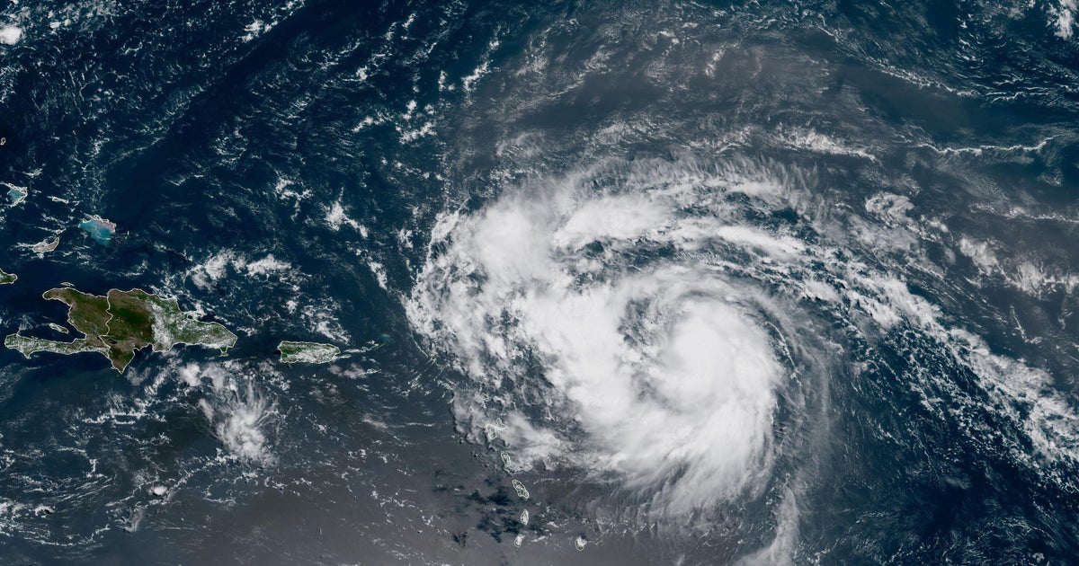
Hurricane Erin has rapidly intensified in the Atlantic, becoming a powerful Category 4 storm. The storm is currently tracking above the northeastern Caribbean and is expected to bring rough surf and strong winds to islands south of its path. This sudden intensification has caught many by surprise and has raised concerns for the safety and well-being of those in the storm's path.
Key Details
The National Hurricane Center has reported that Hurricane Erin's maximum sustained winds have increased to 140 mph, making it a major hurricane. This rapid intensification has been attributed to the warm waters and favorable atmospheric conditions in the Atlantic. The storm is now expected to move towards the northern Caribbean and could potentially bring heavy rains and damaging winds to the region.
Impact
The intensity and track of Hurricane Erin have raised concerns for those in its path, particularly for the islands that are south of the storm's trajectory. Residents and tourists in these areas are being advised to take necessary precautions and closely monitor the storm's progression. The potential for heavy rainfall and strong winds can also have a significant impact on the region's infrastructure and economy.
About the Organizations Mentioned
National Hurricane Center
## Overview The National Hurricane Center (NHC), a division of the National Oceanic and Atmospheric Administration (NOAA), is the primary U.S. agency responsible for monitoring, forecasting, and issuing warnings about tropical cyclones—including hurricanes and tropical storms—in the Atlantic and Eastern Pacific basins[1][3][6]. Headquartered on the campus of Florida International University in Miami, Florida, the NHC’s mission is to save lives, mitigate property loss, and improve economic efficiency by providing accurate, timely, and actionable information to the public, emergency managers, businesses, and international partners[1][2][4]. ## What the NHC Does The NHC operates 24/7, maintaining a continuous watch on tropical weather systems. Its Hurricane Specialist Unit (HSU) issues forecasts, advisories, and warnings, including the Tropical Weather Outlook (four times daily), and detailed forecast packages every six hours during active storms[1][6]. The Tropical Analysis and Forecast Branch (TAFB) supports these efforts with marine forecasts, satellite interpretation, and specialized analyses covering over 10 million square nautical miles[7]. The NHC also coordinates with federal, state, and local agencies, the media, and international meteorological services to ensure consistent, reliable information flow before, during, and after hurricane events[1][5][6]. ## History and Key Achievements Established in the mid-20th century, the NHC has evolved into a world leader in hurricane forecasting, leveraging advances in satellite technology, computer modeling, and data analytics. Over the decades, the NHC has dramatically improved forecast accuracy; for example, the average error in 48-hour hurricane track forecasts has been reduced by more than half since the 1990s[5]. The NHC’s public outreach and education programs have also played a critical role in increasing community resilience and preparedness[1][6]. ## Current Status and Notable Aspects Today, the NHC is on