Southeast U.S. Faces Tropical Storm Threat: Emergency Declarations and Preparations

Southeast U.S. Prepares for Tropical Storm Threat
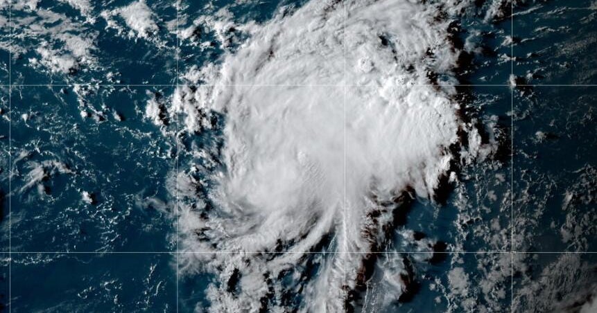
The Southeast United States is on alert as a tropical depression over the Caribbean shows signs of strengthening. The National Hurricane Center warns that this system could intensify into a tropical storm as it moves toward the East Coast, potentially bringing heavy rainfall and strong winds to the region.
State of Emergency Declared
In response to the looming threat, South Carolina's governor has declared a state of emergency to mobilize resources and ensure public safety. Residents are urged to stay informed and prepare for possible flooding, power outages, and hazardous travel conditions that often accompany tropical storms.
Potential Impacts and Precautions
Forecasters emphasize that impacts could extend beyond the storm’s center, with flooding rains and gusty winds affecting a wide area. Emergency officials recommend having an evacuation plan, securing property, and monitoring updates from the National Hurricane Center and local authorities to mitigate risks as the storm approaches.
About the Organizations Mentioned
National Hurricane Center
## Overview The National Hurricane Center (NHC), a division of the National Oceanic and Atmospheric Administration (NOAA), is the primary U.S. agency responsible for monitoring, forecasting, and issuing warnings about tropical cyclones—including hurricanes and tropical storms—in the Atlantic and Eastern Pacific basins[1][3][6]. Headquartered on the campus of Florida International University in Miami, Florida, the NHC’s mission is to save lives, mitigate property loss, and improve economic efficiency by providing accurate, timely, and actionable information to the public, emergency managers, businesses, and international partners[1][2][4]. ## What the NHC Does The NHC operates 24/7, maintaining a continuous watch on tropical weather systems. Its Hurricane Specialist Unit (HSU) issues forecasts, advisories, and warnings, including the Tropical Weather Outlook (four times daily), and detailed forecast packages every six hours during active storms[1][6]. The Tropical Analysis and Forecast Branch (TAFB) supports these efforts with marine forecasts, satellite interpretation, and specialized analyses covering over 10 million square nautical miles[7]. The NHC also coordinates with federal, state, and local agencies, the media, and international meteorological services to ensure consistent, reliable information flow before, during, and after hurricane events[1][5][6]. ## History and Key Achievements Established in the mid-20th century, the NHC has evolved into a world leader in hurricane forecasting, leveraging advances in satellite technology, computer modeling, and data analytics. Over the decades, the NHC has dramatically improved forecast accuracy; for example, the average error in 48-hour hurricane track forecasts has been reduced by more than half since the 1990s[5]. The NHC’s public outreach and education programs have also played a critical role in increasing community resilience and preparedness[1][6]. ## Current Status and Notable Aspects Today, the NHC is on