Bermuda Braces for Category 2 Hurricane Imelda

Bermuda on High Alert as Imelda Intensifies
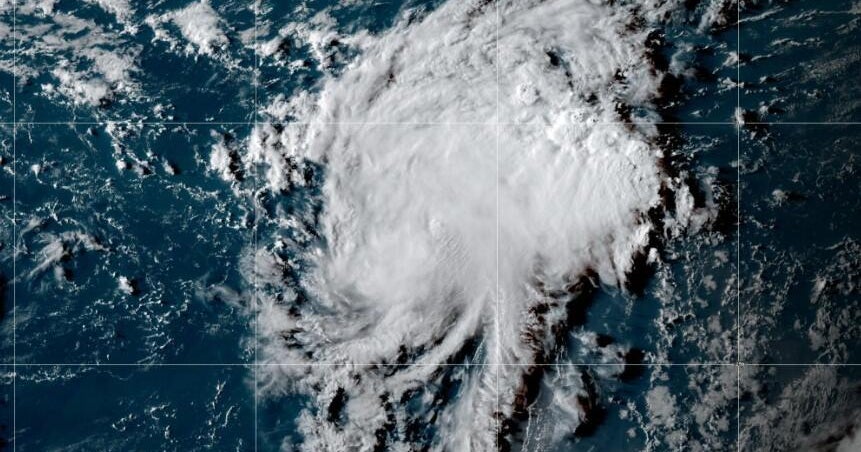
Bermuda is bracing for a powerful encounter with Hurricane Imelda, now strengthening into a Category 2 storm as it approaches the island chain. Meteorologists expect the system to pass over or dangerously close to Bermuda early Thursday morning, bringing the threat of damaging winds, heavy rainfall, and coastal flooding. Residents are urged to stay informed and prepare for possible power outages and transportation disruptions. The Bermuda Weather Service has cautioned that tropical-storm-force winds could persist even after the hurricane’s center moves away, underscoring the lingering risks posed by Imelda’s outer bands.
Community Readiness and Ongoing Response
Local authorities have activated emergency protocols, calling for the public to avoid unnecessary travel and allow crews to clear debris and restore essential services. As of early Thursday, thousands remain without power, with utility teams prioritizing repairs to critical infrastructure. The Minister of National Security has praised the community’s unity and preparedness but emphasized that vigilance remains crucial as unsettled weather continues. The situation serves as a reminder of Bermuda’s vulnerability to Atlantic storms—and the importance of timely warnings and coordinated response to minimize impacts on life and property.
About the Organizations Mentioned
Bermuda Weather Service
The **Bermuda Weather Service (BWS)** is Bermuda’s national meteorological agency, officially recognized as the island’s National Meteorological and Hydrological Service. It provides comprehensive weather forecasts and warnings for public, marine, tropical, and aviation sectors, along with climatological services essential for the island’s safety and planning[2][7]. Established in **1995**, the BWS took over meteorological responsibilities previously managed by a US Navy base stationed on Bermuda, marking a significant step in localizing and modernizing weather services for the island[2]. The BWS plays a crucial role in monitoring Bermuda’s weather, especially given the island’s vulnerability to hurricanes and tropical storms. Their studies have shown that devastating storms historically affect Bermuda roughly every six to seven years, underscoring the importance of accurate forecasting and warnings[5]. The service uses advanced technologies, including a Doppler radar system maintained in cooperation with the Bermuda Airport Authority, which is accessible online and popular among residents for real-time weather updates[1]. Despite recent upheavals in related US meteorological agencies, such as job cuts at the National Oceanic and Atmospheric Administration, the BWS continues its operations without interruption, maintaining key services and training programs such as sending forecasters to the US National Hurricane Center’s tropical workshops[1]. This ongoing collaboration ensures Bermuda remains at the forefront of tropical weather forecasting expertise. The BWS is notable not only for its operational independence but also for its integration into international meteorological networks like the World Meteorological Organization, helping Bermuda stay connected with regional and global weather developments[6]. Its commitment to public safety, technological adoption, and continuous training highlights its role as a vital institution in Bermuda’s infrastructure, blending business, technology, and environmental stewardship seamlessly.