Melissa Intensifies: Tropical Storm Could Become Hurricane in Caribbean

How Tropical Storm Melissa is Intensifying
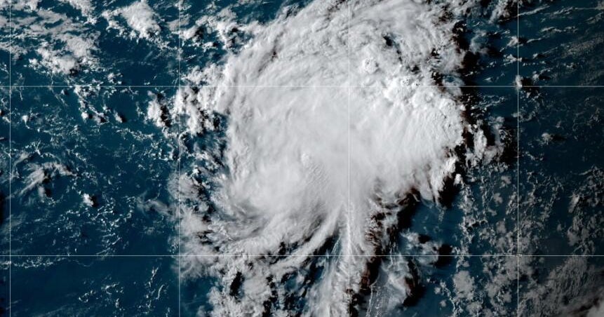
Tropical Storm Melissa formed in the Caribbean Sea and is showing signs of strengthening as it moves westward over exceptionally warm waters. These conditions are fueling the storm's intensification, with sustained winds currently around 50 mph. Forecasters anticipate Melissa could reach hurricane status later this week, driven by the Caribbean's high sea surface temperatures that remain unusually warm this late in the season.
Potential Path and Impact
Melissa is expected to approach Jamaica and Hispaniola by the end of the week, where heavy rainfall ranging from 5 to 12 inches could cause significant flooding. The storm’s future track remains uncertain, with some models suggesting a northward turn toward Hispaniola due to interactions with upper-level winds, while others predict a slower westward drift across the Caribbean. This uncertainty complicates preparations for affected areas.
Ongoing Monitoring and Concerns
National Hurricane Center flights are gathering data to better assess Melissa’s intensity and trajectory. Authorities in Haiti and Jamaica have issued watches due to the threat of strong winds and flooding. As the storm develops, continued monitoring is critical to understand its evolving risks and potential impacts on the Caribbean region.
About the Organizations Mentioned
National Hurricane Center
## Overview The National Hurricane Center (NHC), a division of the National Oceanic and Atmospheric Administration (NOAA), is the primary U.S. agency responsible for monitoring, forecasting, and issuing warnings about tropical cyclones—including hurricanes and tropical storms—in the Atlantic and Eastern Pacific basins[1][3][6]. Headquartered on the campus of Florida International University in Miami, Florida, the NHC’s mission is to save lives, mitigate property loss, and improve economic efficiency by providing accurate, timely, and actionable information to the public, emergency managers, businesses, and international partners[1][2][4]. ## What the NHC Does The NHC operates 24/7, maintaining a continuous watch on tropical weather systems. Its Hurricane Specialist Unit (HSU) issues forecasts, advisories, and warnings, including the Tropical Weather Outlook (four times daily), and detailed forecast packages every six hours during active storms[1][6]. The Tropical Analysis and Forecast Branch (TAFB) supports these efforts with marine forecasts, satellite interpretation, and specialized analyses covering over 10 million square nautical miles[7]. The NHC also coordinates with federal, state, and local agencies, the media, and international meteorological services to ensure consistent, reliable information flow before, during, and after hurricane events[1][5][6]. ## History and Key Achievements Established in the mid-20th century, the NHC has evolved into a world leader in hurricane forecasting, leveraging advances in satellite technology, computer modeling, and data analytics. Over the decades, the NHC has dramatically improved forecast accuracy; for example, the average error in 48-hour hurricane track forecasts has been reduced by more than half since the 1990s[5]. The NHC’s public outreach and education programs have also played a critical role in increasing community resilience and preparedness[1][6]. ## Current Status and Notable Aspects Today, the NHC is on