Powerful Nor'easter Looms Over the East Coast: Forecasts, Impacts & Prep

A Powerful Nor’easter Looms Over the East Coast
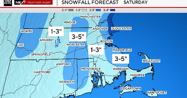
A formidable nor’easter is brewing, potentially slamming the East Coast from Washington D.C. to Boston with heavy snow and fierce winds as early as February 22-24. Forecast models clash dramatically, with most predicting a coastal bullseye delivering 1 to 2 feet of accumulation in the Mid-Atlantic and Northeast, while the Euro model shifts it eastward, sparing major cities but still threatening inland snows of 2 to 10 inches.[1]
Forecast Disagreements and Snow Potential
Major models diverge just days out: American and Canadian guidance show the storm hugging the I-95 corridor, unleashing squall lines of wet snow into New Jersey and beyond, endangering coastal hubs with travel chaos. High pressure trailing could amplify winds, whipping up blizzard conditions in the Ohio Valley and eastern Great Lakes before pivoting northeast.[1]
Impacts and Preparation Tips
Expect power outages, flight delays, and hazardous roads amid La Niña’s lingering chill, though seasonal outlooks hint at milder East Coast temps overall.[2] Stock essentials, monitor updates, and brace for a classic winter wallop that could redefine late February weather.